Dawson House
The soldiers burned their barn, slaughtered the livestock, confined the family to their house, and reportedly used the house for target practice

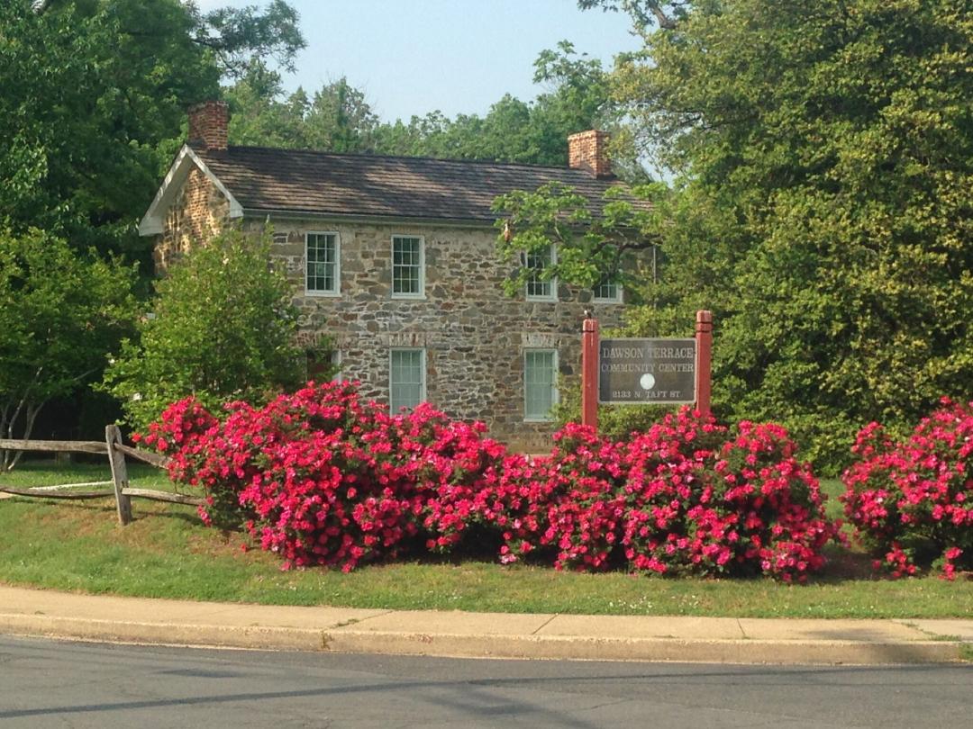
Dawson House, the only surviving building built inside Arlington’s Civil War fortifications.
As the only surviving stone structure in Arlington County from the 18th or 19th century, the Dawson House, located at 2133 N. Taft St., is also the only building still standing that was inside Arlington’s Civil War fortifications. Dawson Terrace – originally known as the “Dawson Bailey House” – was established as early as 1859, when the Dawson Family purchased the 82 acre farm.
The property in which the Dawson House was built on would change hands multiple times before the Dawson family took ownership. Most notably was founding father George Mason IV, who controlled almost all of the Rosslyn and Northern Highlands neighborhoods by 1767. While building his own home at Gunston Hall, the Mason family leased and sold much of his land to local tenant farmers who worked and lived on the land. One parcel of land included the future Dawson property. An 1856 newspaper advertisement announced the sale of a valuable farm at auction-
“containing eighty-two acres… The improvements consist of a good stone dwelling, orchard of peach and apples of choices fruits in thriving condition, an excellent spring of water, with two running streams of water, with Oak and Pine Timber sufficient for fencing and fuel; one half has been in cultivation and other is in good condition”
The stone dwelling mentioned in the advertisement was likely used as a warehouse for crops or housing for tenant farmers and is believed to be a part of the Dawson House today.
The Dawsons, a wealthy family from Maryland, purchased the advertised land for $2,378 in 1859. Thomas B. Dawson moved in by July 1860 with his wife and three young daughters, naming the property “Rio-Vista” (Spanish for “River View”). As soon as Dawson moved onto the land in July 1860, he immediately began to renovate the structure, and is credited with doubling the size of the original stone dwelling. Dawson’s additions are now the eastern half of the building, built to exactly mirror the original structure.
A letter from Thomas Dawson’s granddaughter in the 1950s confirms, “My grandfather…bought the house…in 1859. At that time, there were 85 acres and a small stone house, two rooms, one above the other. It is part of the house as it is today, at the west end. He added the rest of the stone house in 1859.”
Still visible today, Dawson carved his initials, “T.B.D-1859”, into the east side first floor window upon completion of the addition.
The Civil War broke out just two months after Bessie Dawson, the youngest daughter, was born. Strategically, the Dawson house was important due to its position on a hill overlooking Washington. When Virginia voted to leave the Union on May 24th, 1861, the Dawson family ended up in the middle of Arlington’s Union Army Civil War defense ring. While they were lucky to keep the residence as their home, their property was heavily affected by the nearby soldiers, who established Fort Bennett on their property and Fort Corcoran just Southeast of their property.
The soldiers burned their barn, slaughtered the livestock, confined the family to their house, and reportedly used the house for target practice. Because an important military road connecting the forts was laid directly in front of the home, the family needed a special pass to leave the property.
The Dawsons were not alone. Most of the farms along the Potomac were destroyed by Union soldiers in order to build the ring of forts established under the Defenses of Washington. After the war, the Dawson family received $3,369 in reparations for destroyed property and stolen crops from the Union soldiers - much higher than the typical payout of $300-400, indicating an especially high degree of property destruction.
When Thomas Dawson died in 1895, the land was split between his 4 daughters. Over time, as the daughters married and moved away, they began to sell off the surrounding land to developers. Bessie Dawson was the only one who remained in the house, living there with her husband William Conway Bailey. The name “Dawson-Bailey House” originated from this time period, when it was believed that her husband was related to the Bailey family of Bailey’s Crossroads. As this connection has been proven false, the name was changed to “Dawson House” to reflect the family’s importance to the property.
Bessie continued selling off her father's land, and by 1940 there was nothing left of Dawson’s original farm except for the Dawson House. This allowed for the development of Adams Street, Doubleday’s Road (N. Courthouse Road), the Palisades Apartments, the First Church of Nazarene, and the Bay-Eva Castle, which were all built on the former Dawson property.
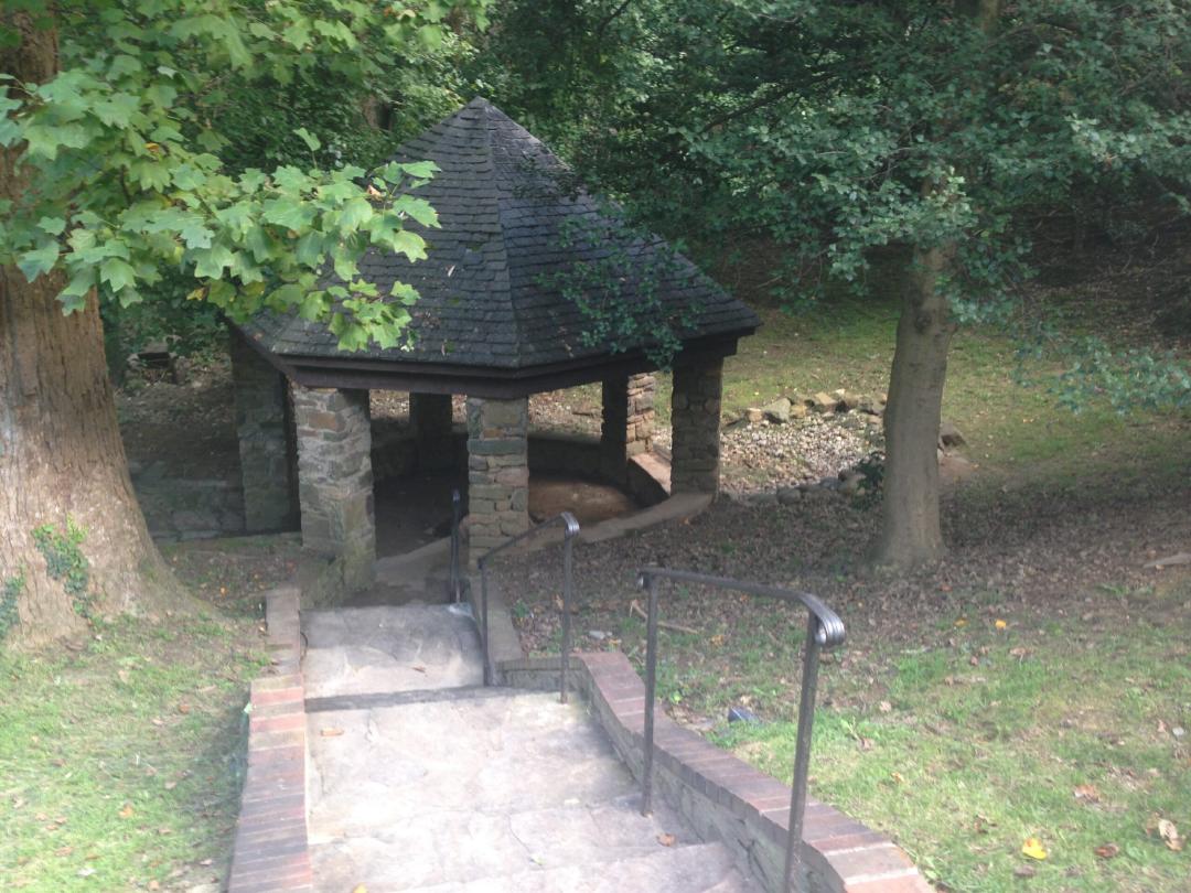
While Dr. Jacobs was constructing the nearby “Bay-Eva Castle” in 1936, he found a spring that once belonged to the Dawson Terrace property enclosed with a small metal roof. According to Bessie Dawson, “her father would take black walnuts from the trees near his home to soldiers camped near this spring. Soldiers were cutting down many trees for firewood, and Mr. Dawson asked them to leave the tulip poplar tree which shaded the spring”. Workers used leftover bricks from the Bay-Eva Castle to construct the current structure surrounding the spring, and the tree is still standing today.
In 1951, Bessie agreed to sell the final acres of her land, except for the house itself, to Arlington County in order to build a playground. Completed a year later, it was dedicated as Dawson Terrace Park to honor her father’s contribution to the area.
Upon Bessie’s death in 1955, the County acquired the Dawson Home to turn it into a teen and community center, adding a modern building with rec space and an auditorium in the early 1960s. In 1996, the Dawson House was designated as a Local Historic District.
Although Dawson Terrace has been in almost constant use since being acquired by the County, the Dawson House itself was only being used for Parks & Rec storage. Since 2017, The Center for Local History has occupied the building for processing archival collections. Today, the Community Center still holds County and community events on the property.
Images

