The Roots of Clarendon
Clarendon has a connection with a number of prominent land owners. George Mason, one of America’s founding fathers, and his son John owned much of what is now lower Clarendon until 1830.
Clarendon is one of Arlington’s most popular destinations for shopping, restaurants, and nightlife. However, many people don’t know its historical origins or connection with one of Virginia’s famous founders.
Clarendon's history has its roots in the colonial era when land grants were issued to William Strutfeld in 1709 and James Robertson in 1729. The earliest vestiges of Wilson Boulevard developed as the “road to the ferry” run by Francis Awbry in 1742. Clarendon grew slowly through the 1700s and 1800s, dominated mainly by farmland until 1900. Cows belonging to the Arlington Dairy Company were still grazing Whalen’s Field (between Franklin Road and Hudson Street) as late as the 1950s!
Clarendon has a connection with several prominent landowners. George Mason, one of America’s founding fathers, and his son John owned much of what is now lower Clarendon until 1830. Robert Cruitt purchased over 400 acres in 1847 for the low price of $1698.93 on September 28, 1847. Cruitt’s home, which still stands today, was used as a hospital during the Civil War and later as a dairy farm. Twenty-five acres of Cruitt’s land was sold to Mary Nesmith for $25 an acre ($625 total) in 1897, which she sold only two years later for $8000. Robert Treat Pain, a man who would significantly impact Clarendon in the future, bought those 25 acres in 1900.
On March 31, 1900, the “Town of Clarendon” was officially dedicated, possibly originating from Robert Treat Pain’s old street in Boston, Clarendon Avenue. A parade featuring five local Volunteer Fire Departments commemorated the monumental event. A real estate firm began advertising the lots for sale at $90 to $140 for a $2 down payment and a dollar a week without interest. To further attract people to the Clarendon area, they offered free trolley rides to and from D.C. for an entire year to the first 50 purchasers. This deal sold out so quickly that five “Additions to Clarendon” had already been platted in ten years. The introduction of Clarendon’s own trolley train station (introduced in 1904 and shut down in 1935) lured in even more residents, and by 1920 the town had over 2000 residents.
In 1748, George Mason received a charter to operate a ferry from Maryland. The ferry crossed the Potomac River from High Street in Georgetown to Mason's Island.
John Mason (1766-1849) married Anna Maria Murray of Annapolis, Maryland, in 1796. They had ten children. Mason's inheritance included properties in Georgetown, the District of Columbia, Virginia, and Mason's Island. In the early 1800s, Mason built a summer residence on the island. In 1805, he had a causeway built to connect the island with the Virginia shore.
By an enactment of the Virginia General Assembly in 1798, John Mason was approved to establish a town on ninety acres of land, which subsequently became Rosslyn. Mason had lots, streets, and alleys laid out for his proposed town, which was to be named South Haven. Several houses were built in South Haven near the ferry, but the city Mason envisioned never materialized.
As a result of a succession of business reverses, John Mason borrowed large sums of money from the Bank of the United States in Washington, D.C. These business problems eventually led to his financial downfall as Mason could not pay back the money on the promissory notes from the bank. In time, the bank took over Mason's properties in Washington, D.C., and the eighteen hundred twenty-two acres in Virginia, with one exception: Mason was able to retain a farm of three hundred acres four miles west of Alexandria called Clermont. Mason's loss during the years 1825-1833 was not only the land but all the improvements, which included farms, farmhouses, outbuildings, mills, the town of South Haven, which was also described in deeds as West Haven, the ferry, the ferry landing, and in Washington, numerous lots, houses, and business properties.
The president and directors of the Bank of the United States named their cashier of the Office of Discounts and Deposits as trustees for the disposition of the Mason properties. In 1836, a survey was conducted on eighteen hundred twenty-two acres in Virginia. The surveyor, Lewis Carberry, subdivided the land into sixty-nine parts, with forty-three quarry lots on the riverbank and twenty-six lots or sections inland. Section 15 and the south part of Section 9 were purchased by Robert Cruitt on September 28, 1847, from Robert Widdicomb for $1698.93. Widdicomb bought it from the bank. 18 Lot 5 of Section 15, containing approximately thirty-four acres, was the site of present-day Clarendon.
The owners of Lot 5 between 1856-1 870 were Amos Denham of Loudoun County; Andrew Hoover; his son, Andrew P. Hoover; Jonah D. Hoover, who paid $68.00 per acre; Josias Harrison Knott, who paid $3393.75; and Arthur S. Nesmith, who paid 54000.00. Except for Denham, all the owners were from Washington. Mary E. Nesmith, the widow of Arthur S. Nesmith, sold twenty-five of the approximate thirty-four acres to Robert Sprague Hall of Boston, Massachusetts, on October 18, 1897, for $8000.00. Shortly after Hall purchased the land, he sold it to Robert Treat Paine, Jr., also from Boston. Paine subdivided the land into lots and streets and dedicated his Plan of Clarendon on March 31, 1900, by Chapter 483 under the Acts of the Assembly of Virginia of 1887 and 1888.
Robert T. Paine, Jr. employed Wood, Harmon, and Company of Washington to handle the sale of his land. A promotional brochure in the Arlington Historical Society's Archives gives insight into the sales technique used by the real estate company. The brochure emphasized Clarendon's natural features, its accessibility to Washington, and its ideal suburban location, which offered home seekers a perfect place to live as could be found anywhere near Washington.
The following incentives were used to stimulate the immediate development of Clarendon:
1. The first twenty-five people buying property who agreed to begin building by June 1st and occupy their houses by November 1st were given cash prizes of $100.00 to $300.00.2. Commuters to Washington were to be given free trolley rides for the first two years of their residence in Clarendon. The Aqueduct Bridge, which Key Bridge subsequently replaced, was only eight minutes by trolley from Clarendon.
3. The developer provided All improvements, including gravel roads and sidewalks, free of charge.
4. Lot owners who paid fifty cents a year per lot to the Clarendon Improvement Society were promised that the society would continue to care for lots and streets, keeping them in park-like condition.
This small community increased in the early 1900s, as prices for acres sold for $90 in 1915 skyrocketed to $285,000 by 1985. In 1913, gas, water, and electricity were made available for all Clarendon residents, and by 1914, Clarendon was one of the first counties in the nation to have zoning regulations.
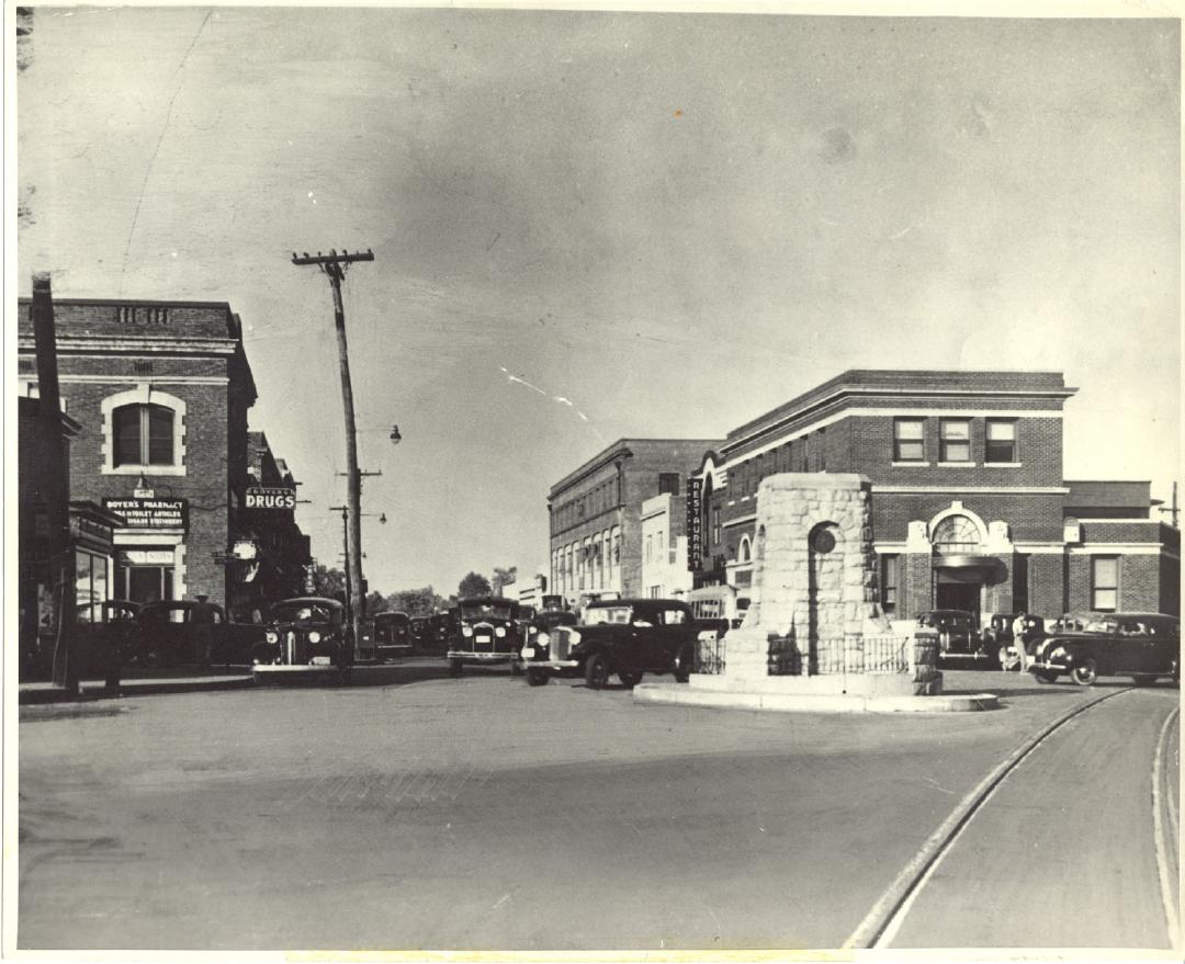
Aside from its popularity as a residential area, Clarendon also gained its title as Arlington’s “downtown” area in the early 1900s. By 1920, there were three general stores, numerous specialty shops (including a bakery, hat shop, and Boyers’ Pharmacy), and more than ten restaurants. Clarendon was home to the first oyster bar in the country and the first Masonic Lodge in Arlington. The Clarendon Bank, a famous landmark, opened in 1920 and remained until it shut down for development in 1974. Some other noteworthy commercial landmarks include Joyce Motors (which sold gas at 2 cents a gallon to firefighters in the 1940s), Kirby’s Garage(known for its art deco structure), Hurt Cleaners (a notoriously seedy pool hall in the 30s), and the “telephone company” (where Merton E. Church established an early switchboard). Clarendon was a popular shopping center in the 50s as well.
Another famous landmark is the War Memorial, which began as a plain white cross in 1919 to honor American victims of World War I. In 1931, it was replaced by a stone column, but the new monument kept being damaged by out-of-control cars, so it was rebuilt in the Courthouse as a three-level structure with Civil War cannons, a large stone eagle, and a bell.
In 1937, the opening of the Main Arlington Post Office in Clarendon stirred the county. It symbolized Arlington's unification, as all the small community post offices were consolidated into this one general office. Until 1937, all of Arlington’s mail was handled in Washington, D.C. The post office is now a historic landmark. Around the same time, the New Deal’s WPA(Works Progress Administration) also painted several famous murals as a beautification project for the Clarendon area.
Clarendon continued to boom until the 1960s when the introduction of large shopping malls began to steal business from the area. As Clarendon declined in the 1960s and 70s, many ethnic groups moved in and revitalized the flagging urban center, consequently gaining the nickname “Little Saigon.” This lifestyle continued for about 15 years until Clarendon was connected to the Metro, bringing high-rise construction. Clarendon is still in its century-old transformation, with an ever-evolving combination of new restaurants, well-known national stores, small eclectic businesses, and residential homes. With its unique character, walkability, and charm, we know Clarendon will remain Arlington’s downtown center for years.
Images