Spy Hill
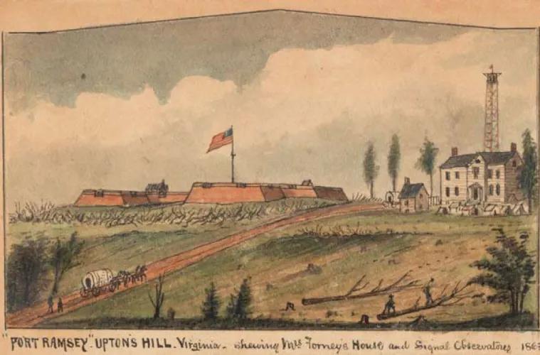
The Federal army established Fort Ramsay on Upton’s Hill as part of the defense of Washington owing to the ability to see the Washington Monument and the Capitol from this vantage point.
Spy Hill was originally comprised of two land grants, the Thomas Pearson grant of 1707 (660 acres), and the John Ball grant in 1742 (166 acres). The Pearson property was leased in 1740 for clearing and cultivation, while the Ball property, which included the log cabin erected by John Ball, known as the Ball-Sellers house, was sold as small lots around 1835. Together, these two areas became known as Boulevard Manor.
In 1851, New York farmer Timothy Bishop Munson and his family moved to Fairfax County. Munson started a nursery and raised sheep on the land known as Munson’s Hill, now part of present-day Arlington, which included the more significant portion of Boulevard Manor.
During the Civil War, Confederate forces established an outpost on Upton’s Hill, where the regional park is now located, from which they could observe troop movements across the Potomac. When the Confederate army withdrew from this area, the Federal army established Fort Ramsay on Upton’s Hill as part of the defense of Washington, owing to the ability to see the Washington Monument and the Capitol from this vantage point. The areas of Boulevard Manor and Fort Ramsay received the name Spy Hill due to these activities. The image above is a Harper’s Weekly sketch of Union troops on Spy Hill.
In the 1860s, William A. Torreyson purchased land from the Carlin and Munson estates, including a sizeable portion of Munson’s Hill, and established a dairy farm. Torreyson’s daughter Lucy married George Reeves in 1894. They took over the dairy farm in 1902, the last to operate in Arlington, until closing in 1955 under the ownership of George Reeves’ son, Nelson. After its sale in the late 1970s, Spy Hill was a popular gathering place for teenagers until its eventual development in 1990.
Images